Sign on to Protect Homer's Quality of Life as we Grow.
Homer recently created a Comprehensive Plan where public input was given on what we want for our community: an overwhelming majority of us said we wanted to protect open spaces from development, moderate growth, walkability, recreational access, protection from hazards like flooding and landslides, and affordable housing. These values are essential to a thriving community at the end of the road.
PLEASE SIGN HERE TO SUPPORT CHANGES TO CITY CODE THAT SUPPORT OUR ENVIRONMENT AND QUALITY OF LIFE!
City Code Should Support: Density & Walkability, Use of Environmental Information to Guide Growth, Creek and Wetland Protections, and Huge Developments Meet Community Needs.
Density & Walkability not Massive Buildings
The City is proposing to change code to allow 30,000 SF buildings without any kind of permit or public comment. Anywhere in town. For referene, this is about the size of Safeway. The city's proposal would redefine "large format developments" as buildings over 30,000 square feet, rather than the current limit of 15,000+ square feet (about the size of the Aspen Suites Hotel). We oppose this. Permits should be required for buildings over 15,000 square feet. In the comprehensive plan process, 2/3 of folks said wanted moderate development, density and walkability. Huge buildings with huge parking lots are the opposite of that. We also oppose decreasing the number of public meetings for "large format developments" from two meetings (current code) to only one meeting (proposed code).
On top of that, the City is proposing to allow 75,000+ square-foot buildings in the Light Industrial Mixed Use Zone and in the Gateway Business District. This would mean, eg., that you could have a Walmart along Kachemak Drive, or at the top of Baycrest and/or where Pioneer meets the highway. Retail and Wholesale buildings of this scale are currently prohibited throughout Homer, based on a rule designed to keep box stores out of Homer and keep small and mid-size businesses thriving. We should keep a hard prohibition on box stores everywhere in town, and we should extend the limitation it to include hospitality.
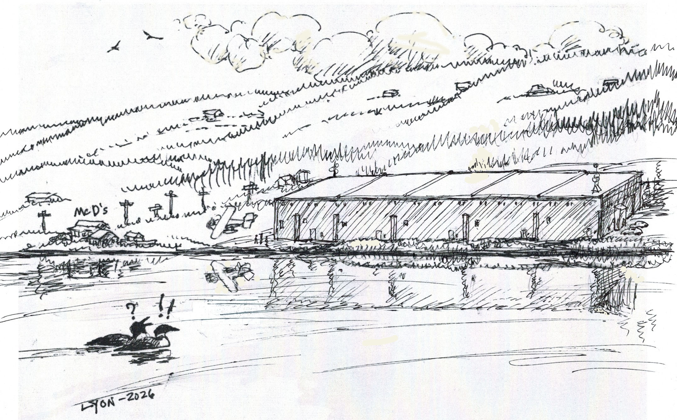
It is important for the Planning Commission to review large buildings to ensure site-suitability, parking, lighting, connectivity, etc. Yet the City is proposing to get rid of this requirement and to replace it with percentage-of-lot standard, which could make for some huge buildings in inappropriate places (see sketch above). This proposed change is against the recommendations of the public and the Planning Commission. The City should continue to require a Conditional Use Permit for buildings over 8,000 square ft. in the Downtown Mixed Use Zone and Gateway Business Zone.
Larger developments should be required to create park space and connectivity/walkability with other parts of the city. The public appreciates places where they can walk and see wildlife: parks raise property values, mitigate flooding, and improve quality of life. If developments go in adjacent to trails or bike paths, they should ensure connectivity.
Use Information about our Environment to Guide Development.
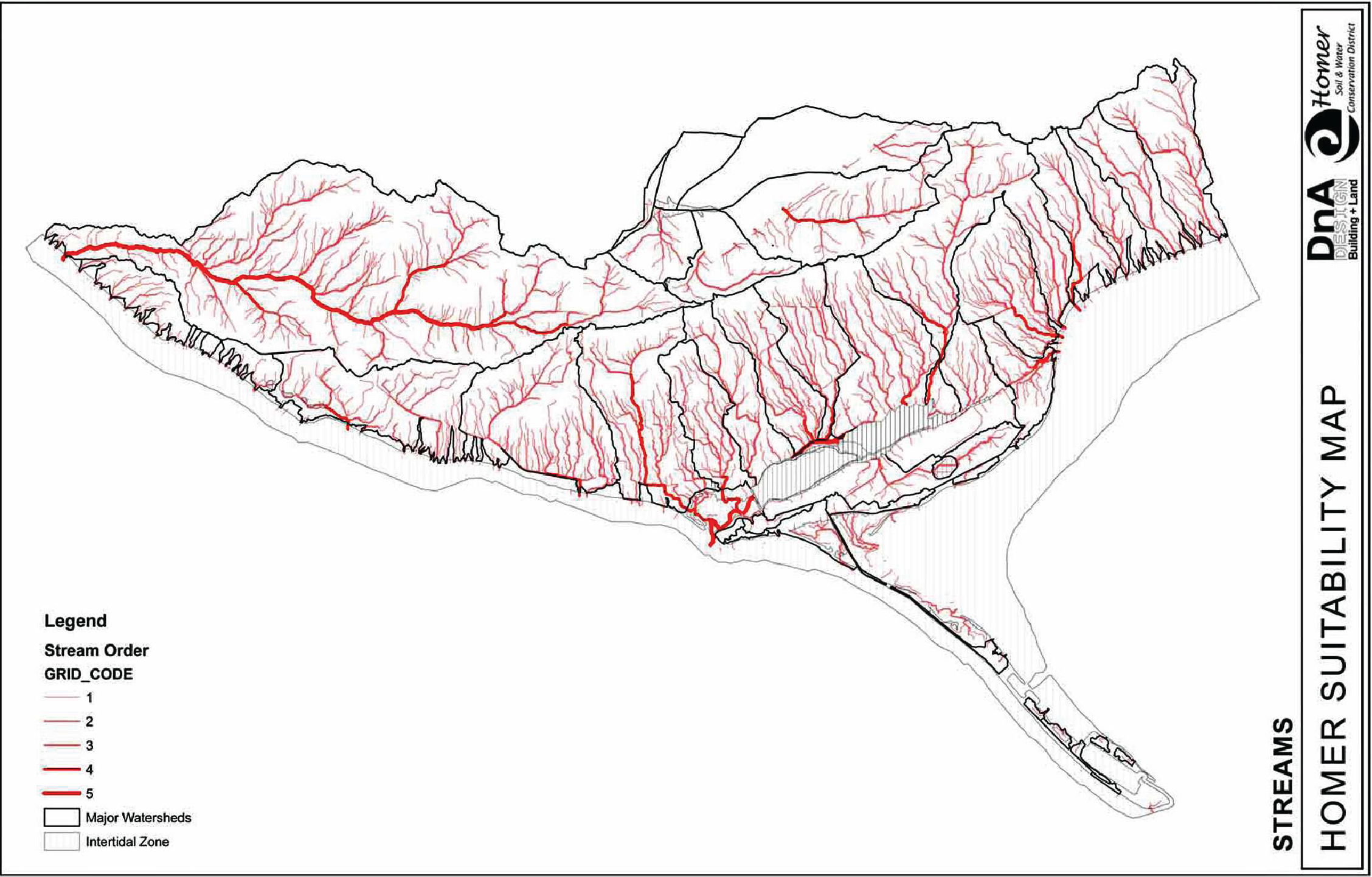
Existing GIS mapping that shows low-, medium- and high-value wetlands, water flow, slope instability, and critical habitats should be used to guide what kinds of developments go where. This data is on-hand, easy to use, and will improve safety, property values, and quality of life. It will protect folks from the hazards of flooding, septic failure, etc. and it will also ensure that some of our highest-value wetlands (think deep peat) and habitats (think shorebird habitat in Mud Bay) only have low-impact development on them. This doesn't have to be too complicated or expensive. Models for using this type of data to guide development exist in many towns across the USA, including some good examples in Anchorage and across King County, Washington.
Focus on Creeks and Wetlands.
Require Clear, Fill and Grade Permits for development in sensitive sites like steeper slopes, high-value wetlands, or areas with large amounts of water moving through them. Mismanaged stormwater is a problem all over Homer and can lead to flooding, ice, clogged drainages, septic system failures, and more. We have to be careful with cutting and rerouting water in these areas to protect folks downstream. For a good model, take a look at King County, Washington..
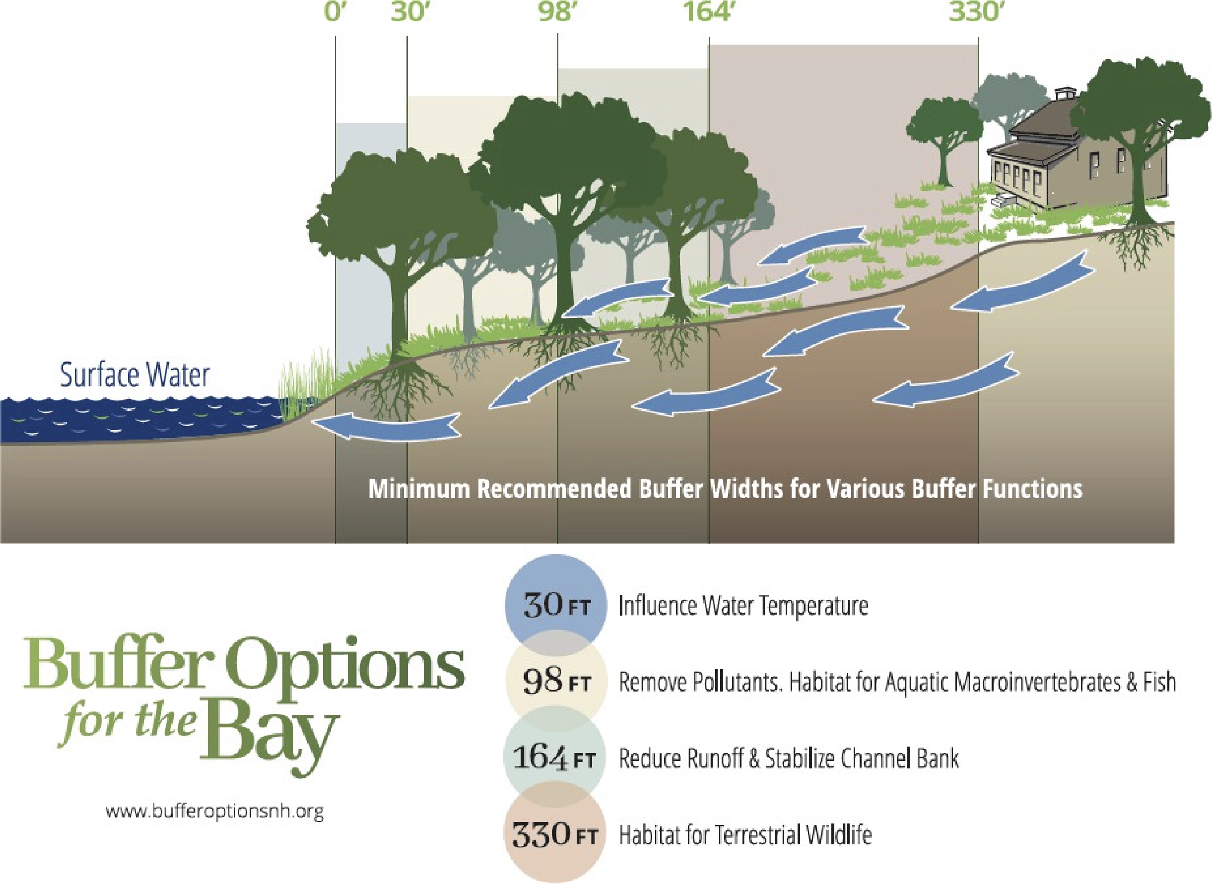
Establish vegetated buffers around creeks and wetlands designated as “medium-” and “high-priority” by the Kenai Peninsula Borough. Mismanaged stormwater is a problem all over Homer that leads to flooding, dangerous roadway icing, clogged drainages, septic system failures, increasing costs and hazards for the city and the public. The EPA has a model ordinance for instituting local buffers. The Kenai Peninsula Borough already has buffers around all anadromous salmon waters; the Bridge Creek Watershed already has buffers around creeks - all of which could be used as models to establish relevant code.
Expand the language describing the kinds of conditions that can be placed on Conditional Use Permits (Homer City Code, 21.71.040) to include measures maintaining riparian waterways, soil stability, woodlands, vegetation, wetland protection, and water quality. These considerations are supported by language throughout the Comprehensive Plan indicating the need to manage hazards associated with stormwater, such as flooding and erosion, and it aligns with the basic legal principle that governments have the power to protect people from harm caused by other people.
Ensure Large Developments Fit Community Needs
Sometimes we need larger buildings, like the high school or hospital. But the permit that allows for these larger buildings -a "Planned Unit Development" permit or PUD - is also loophole that lifts the lid on development guidelines, like height and footprint, anywhere. It opens the door for unequal application of the law, is vague and confusing. Code should specify that PUDs are only for projects that will benefit the community, like schools, rec. centers, hospitals and essential infrastructure. Structures such as a large hotel, box store, data center, prison, or cruise ship facility should not be considered for a PUD.
 Click Here for More Information